Only by going alone in silence, without baggage, can one truly get into the heart of the wilderness.
John Muir
I was pleased last week when a reader recognized the trail I described in my tale of cold and warmth and knew it to be one that has been long abandoned. The Boundary Trail once spanned the width of the Pastayten Wilderness from Horseshoe Basin in the east all the way to Ross Lake. The long trail was so named because it paralleled the border with British Columbia. A portion of that trail remains, from Horseshoe Basin to Castle Pass, and makes up a segment of the Pacific Northwest Trail, but past Castle Pass to the west it is now no longer visible and does not appear on maps.
The Pasayten Wilderness has burned extensively in the last several years, some areas more than once, and that vast wild place where I hiked every summer for almost twenty years is now greatly changed, and many of the trails are no longer passable and do not appear on maps.
In researching old routes for this post I was pleased to find a Pargeter’s pictorial map of the North Cascades East, a wonderful find. It is torn along many of the fold lines but otherwise readable. There was no date on it, but my notes indicate that I used this map as early as 1980. I did not use the map on the trail, as it did not provide sufficient detail for accurate route finding, but it was great for planning my routes in advance.
In the early 1980’s obviously there were no trail apps, no social media posts about trail conditions, not even guidebooks for the more remote areas like the Pasayten Wilderness. When exploring an area that was new to me I would spread out a map, study the trails, and plan my route. Typically I had no idea what kind of rugged territory I would be entering, apart from what I could surmise from the map. It obviously did not describe trail conditions. I liked it that way. The trails I explored are marked with felt tip pens, color coded by year. It is like reading one of my old journals. Here and there are notes about nice campsites, good water sources, difficult route finding.
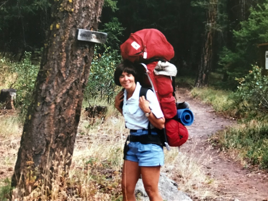
Even at that time many of those routes received infrequent trail maintenance. The year after the trip I described in my last post I started my next Pasayten hike at a trailhead near the Lost River. The trail ascends a steep south facing slope via switchbacks. It was an unrelenting hot day, and I ran out of water about half way up, carrying that heavy pack you see in the photo above.
I sometimes look at photos like that and ask myself, “What was I thinking?” But I know very well what I was thinking. I was young and strong and wanted an adventure in an isolated wild place. That is exactly what I got.
Finally I crossed Pistol Pass and made camp that night at Lake of the Woods, elevation 6500 feet. I had climbed more than four thousand feet that day. I thought the rugged part of the trip was behind me, but that was before I confronted the Ptarmigan Creek Trail the next day. That trail was not particularly steep, instead descending gradually for about three-and-half miles towards the junction near Hidden Lakes. I had anticipated the hike could be done in a couple of hours. Instead it took me all day.
The trail had obviously not been cleared in several years and extensive blow downs blocked my path, some as high as fifteen to twenty feet and several meters wide, requiring that I scramble up, under, and around piles of logs. I still bear a scar on my right elbow where I scraped it on a twig crossing one of those piles. In retrospect, it seems a minor wound, given the challenges I faced that day and the dangers it presented. About a quarter mile before reaching the trail junction the stream bank became too steep to follow, so I waded Ptarmigan Creek in hip deep cold water, which turned out to be easier than scrambling over logs. When at last I arrived at the junction a sign pointing to the route I had just completed stated simply, “Trail Abandoned.”
I spent that night at a lovely campsite on Big Hidden Lake, where I listened to and watched two loons carry their family on their backs. I sat by the shore and called to them, and they came close to me, as if curious. I had not seen a single person since starting my trip two days earlier. Loons would do.
This spot became a favorite site for me, and I returned to it almost every year when I hiked in the Pasayten. There was of course a much easier route to get there which started at Billy Goat Trailhead, a wonderful starting point for many adventures in the Pasayten. But I was not done scrambling across the large Wilderness Area on abandoned trails and the following year would again confront the Ptarmigan Creek Trail, approaching it from another lost route across Shell Rock Pass, some of the most remote and magnificent scenery I have ever seen, with sheer cliffs rising high above the trail, high above where this woman walked alone on an abandoned trail.
I made camp by a small stream west of Shell Rock Pass. Again I had not seen another person since leaving the trailhead two days earlier. Mt. Lago and Blackcap Mountain rose above me, their summits soaring to 8500 feet. I was a small woman in a big place, surrounded by the expanse of the Pasayten Wilderness, an area the size of Rhode Island, and I was alone.
Lost trails never really go away. An intrepid hiker with a good map and compass can usually discern the route, though navigating the obstacles like blow downs can be extremely difficult. Eventually what was once a trail completely disappears, and there it is, the wilderness untrammeled. Perhaps that is as it should be.
These days most hikers seek out the popular trails and value the trail community more than any other aspect of the hiking experience. To have completed such a long route as the PCT, AT, or Continental Divide Trail, otherwise known as the Triple Crown, is indeed an accomplishment deserving of boasting rights.
But there it is this. Have you ever camped alone on an isolated trail far from other hikers? Have you explored the routes that still exist but are hard to find? Have you, as John Muir said, really gone into the heart of the wilderness?
Colleen Drake (AKA Teacup) has over sixty years of hiking exerience (yes, I'm really old) and has seen some pretty big changes over those many years. Join her on the Solitude Trail & share some of these adventures while exploring with her the value of solitude in the wilderness.
View more posts

Food for thought. I need to think About that.
I tend to solo hike where I think if I
<
div>
LikeLike